Kissimmee's 11 areas, from downtown to Lakeside: ZIP codes, zoned high schools and Zillow home values, built from city maps and 2026-27 school zones.
Last checked Oct. 9, 2026. Sources: the City of Kissimmee’s Zoning and Future Land Use Atlas (city limits, redevelopment area, future land use, mobility district and parcel layers), its Community Redevelopment Agencies page and 2040 Comprehensive Plan, the School District of Osceola County’s 2026-27 attendance zones, the Florida Department of Education’s 2026 school grades, Zillow Research, the Census Bureau’s QuickFacts and OpenStreetMap.
Kissimmee sits on the north shore of Lake Tohopekaliga in Osceola County. The city limits cover about 22.8 square miles on the city’s map, and the Census Bureau’s 2020-2024 American Community Survey counts 81,479 residents. The city is not one compact block: it reaches north to Osceola Parkway, west past Bass Road and east across Florida’s Turnpike, with pockets of unincorporated county land in between.
Two roads organize it. U.S. 192, called Vine Street through the city, runs east to west across the middle, and John Young Parkway runs north to south through downtown. Florida’s Turnpike crosses the east side, with exits at U.S. 192/441 (exit 244) and Osceola Parkway (exit 249). I-4 is about 8 to 14 miles west by road, depending on the area.
What this means for you
- Check the city limits first. Kissimmee’s four ZIP codes, 34741, 34744, 34746 and 34743, all reach outside the city. A Kissimmee mailing address in unincorporated Osceola County gets county services, not city ones.
- School zones do not follow city limits or ZIP codes. Homes inside the city are zoned for five different high schools in 2026-27.
- Home values differ by ZIP code: Zillow’s August 2026 figures run from $284,955 in 34741 to $380,668 in 34744.
The areas at a glance
| Area | Main ZIP code | Zoned high school, 2026-27 | Typical home value in that ZIP, August 2026 | Homes |
|---|---|---|---|---|
| Downtown | 34741 | Osceola High | $284,955 | 1,694 |
| Vine Street | 34741 | Osceola High (77%) | $284,955 | 2,245 |
| Tapestry | 34741 | Osceola High (92%) | $284,955 | 1,993 |
| Flora Ridge | 34741 | Osceola High | $284,955 | 3,858 |
| Shingle Creek | 34741, 34746 | Celebration High (62%) | $284,955 | 2,687 |
| North John Young Parkway | 34741 | Osceola High | $284,955 | 8,453 |
| MLK Boulevard | 34741 | Osceola High (95%) | $284,955 | 2,410 |
| South John Young Parkway | 34741, 34746 | Osceola High (51%), Liberty High (49%) | $284,955 / $357,183 | 2,101 |
| Bass Road | 34746 | Poinciana High | $357,183 | 2,411 |
| Mill Slough | 34744 | Gateway High (93%) | $380,668 | 3,286 |
| Lakeside | 34743 | Gateway High | $338,029 | 2,836 |
Home values are the Zillow Home Value Index, a modeled typical value for the middle third of homes in each whole ZIP code, not a sale price. Zillow’s figure for Kissimmee as a whole was $355,971, down 3.2% from August 2025. Homes are living units on residential parcels in the city’s parcel layer. Percentages are shares of each area’s homes; where none is shown, every home has the same zoned school.
Map
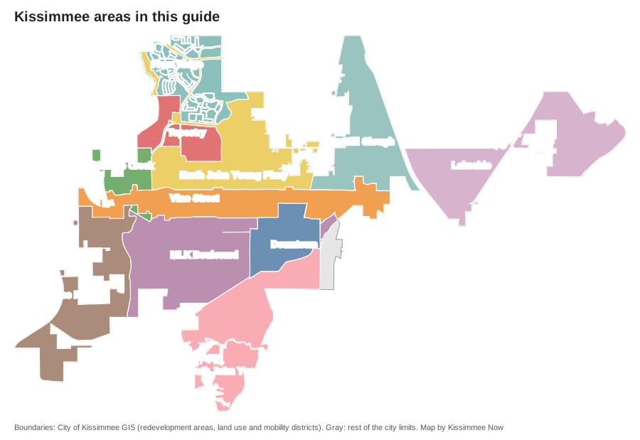
Map: area boundaries from the City of Kissimmee’s GIS layers. Store locations and road distances on the area pages use © OpenStreetMap contributors.
The areas
Downtown. The Downtown Community Redevelopment Area, about 726 acres from Vine Street to the lakefront, with Lakefront Park, City Hall, the SunRail and Amtrak station and the South Beaumont historic district. Its homes have a median build year of 1948.
Vine Street. The city’s second redevelopment area, nearly 5 miles of U.S. 192 from Bass Road to Denn John Lane, with Orange Gardens and many of the city’s supermarkets. Its homes cross four high school zones.
Tapestry. A 568-acre mixed-use land use district on Carroll Street, approved for up to 2,910 homes. Every home there was built after 2010.
Flora Ridge. The mixed-use district south of Osceola Parkway, with about 3,860 homes, a Publix and Flora Ridge Elementary. Closest to the SR 417 toll road.
Shingle Creek. Apartments and condos along the creek between Carroll Street and Vine Street, next to Shingle Creek Regional Park. Most homes are zoned for Celebration High.
North John Young Parkway. The most populous area by our count, about 8,450 homes, mostly apartments and condos, with Kissimmee Elementary, Highlands Elementary and Kissimmee Middle.
MLK Boulevard. Older streets west of downtown and the land around Kissimmee Gateway Airport, with Osceola High School and Oak Street Park.
South John Young Parkway. Newer single-family homes south of Clay Street, including The Oaks and Osceola Village Center. Its high school zone is split between Osceola High and Liberty High.
Bass Road. All single-family homes in ZIP 34746, zoned for Poinciana High, with 90% of the land in the city’s Short-Term Rental Overlay.
Mill Slough. Single-family subdivisions between Michigan Avenue and the Turnpike, with Mill Slough Park, Mill Creek Elementary and the Tupperware SunRail station at its northern edge.
Lakeside. The city’s land east of the Turnpike, mostly in ZIP 34743 and zoned for Gateway High, about 10.3 miles from Orlando International Airport.
For the city’s schools, see our schools guide; for prices over time, our home prices guide; and for taxes inside and outside city limits, our property taxes guide. To compare Kissimmee with nearby cities, see Kissimmee vs St. Cloud vs Belle Isle vs Orlando.
Where the schools fall
From the School District of Osceola County’s 2026-27 zone files, matched to every residential parcel inside city limits, with each school’s grade from the Florida Department of Education:
| High school | Share of city homes | Florida 2026 grade |
|---|---|---|
| Osceola High | 65% | C |
| Gateway High | 18% | B |
| Poinciana High | 8% | B |
| Celebration High | 6% | B |
| Liberty High | 4% | C |
Nine elementary zones and a K-8 zone reach into the city. Check any address on the district’s school locator maps.
How we built this
We found no list of named neighborhoods published by the city, and OpenStreetMap has no neighborhood or suburb names inside the city limits. So we drew the areas from the city’s own map layers:
- Downtown and Vine Street are the boundaries of the city’s two community redevelopment areas.
- Tapestry and Flora Ridge are mixed-use districts on the city’s future land use map, each described in a policy of its comprehensive plan.
- The other seven follow the city’s mobility districts, which the city numbers but does not name. We named each for its main road, its park or the name the city uses for a park or development inside it, and each page says which.
Together the 11 areas hold 99.7% of the homes in the city’s parcel layer. The rest, about 117 homes along Neptune Road east of downtown, fall in a small mobility district without its own page. We counted homes and build years from the city’s parcel layer (Osceola County Property Appraiser records), matched each residential parcel to the school district’s 2026-27 zone files and to its ZIP code, and measured road distances on the OpenStreetMap network on Oct. 9, 2026.
Frequently asked questions
What are the neighborhoods in Kissimmee?
This guide splits the city into 11 areas drawn from city map layers: Downtown, Vine Street, Tapestry, Flora Ridge, Shingle Creek, North John Young Parkway, MLK Boulevard, South John Young Parkway, Bass Road, Mill Slough and Lakeside.
What ZIP codes are in Kissimmee city limits?
Four: 34741, with about 63% of the city’s homes, 34744 (17%), 34746 (14%) and 34743 (7%). All four also reach outside city limits, so a Kissimmee mailing address does not mean a home is in the city.
What high schools serve Kissimmee?
In the 2026-27 zones, 65% of homes in city limits are zoned for Osceola High, 18% for Gateway High, 8% for Poinciana High, 6% for Celebration High and 4% for Liberty High.
What is the typical home value in Kissimmee?
Zillow put it at $355,971 for the city in August 2026. By ZIP code it ranged from $284,955 in 34741 to $380,668 in 34744.
Which part of Kissimmee is closest to Orlando International Airport?
The Lakeside area east of Florida’s Turnpike, about 10.3 miles by road. Downtown is about 16.4 miles.
Have your say